
Storm Austen from the Atlantic to the North Sea: what buoys and satellites measured
A 19.4 m wave at Pierres Noires, 13.2 m seen by Jason-3, 158 km/h gusts on Ushant: Storm Austen's path, 22–24 October 2026, told by buoys, weather stations and satellites.
Storm Austen crossed the Atlantic, the tip of Brittany, the Bay of Biscay, the English Channel and the North Sea in just over 48 hours, between Thursday 22 and Saturday 24 October 2026. I went through every measurement available on The Buoy along its path: buoys, coastal weather stations, and the altimetry satellites that measure wave height from space. Here is its story, in numbers.

Austen's path, step by step
Thu 22, 5pm
The swell builds offshore
- 9.5 mSentinel-6, mid-Atlantic
- 8.8 mSWOT, a few hours earlier
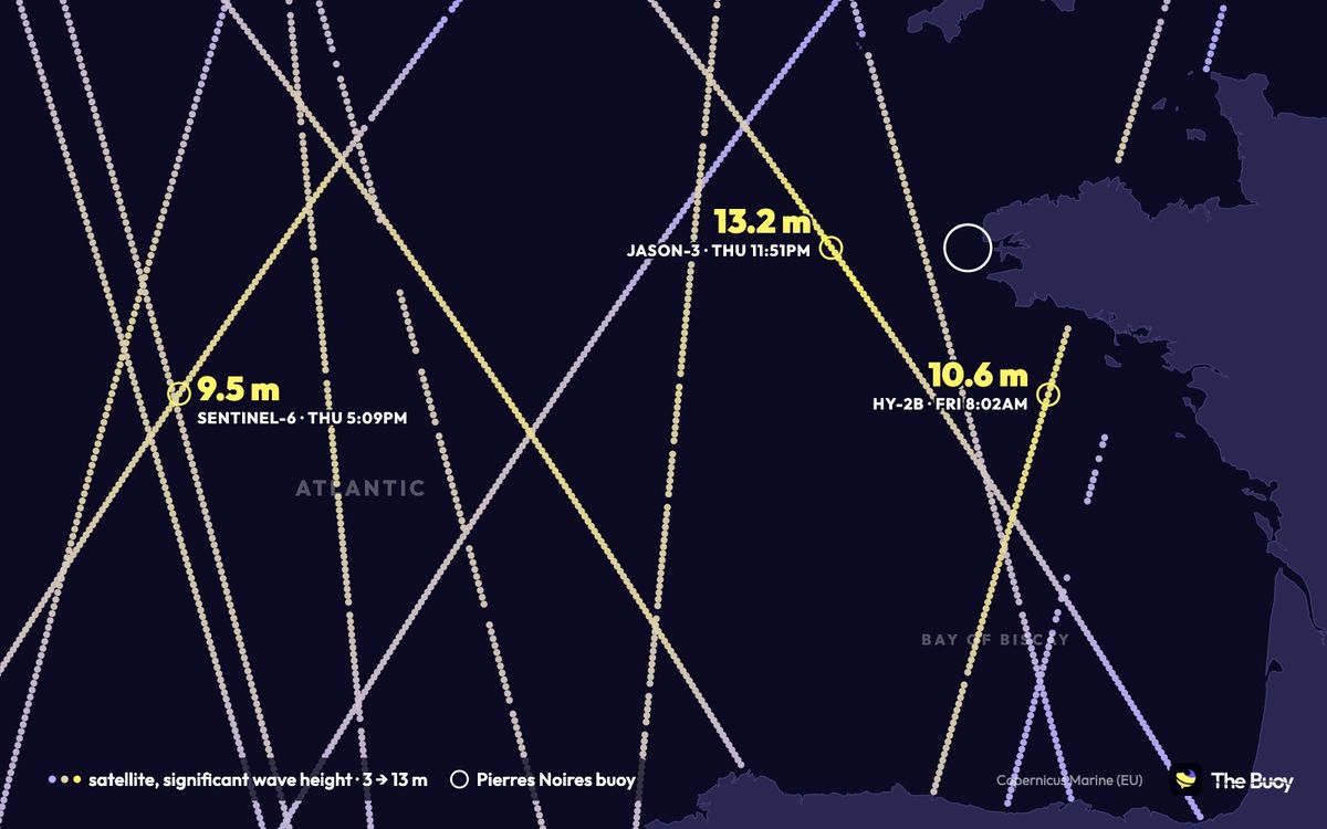
On Thursday afternoon Austen is still in the middle of the Atlantic. No buoy floats out there, but satellites pass over. At 5:09pm, Sentinel-6 measures a significant wave height of 9.5 m near 47°N 15°W, more than 700 km off the French coast. A few hours earlier, SWOT had already recorded 8.8 m in the same area.
Significant wave height is the average of the highest third of the waves. It is what buoys and satellites report and what The Buoy shows. The biggest single waves are roughly twice as high.
Night of 22–23
Brittany takes the first hit
- 19.4 mhighest wave at Pierres Noires →
- 13.2 mJason-3 off Ushant
- 158 km/hgust on Ushant
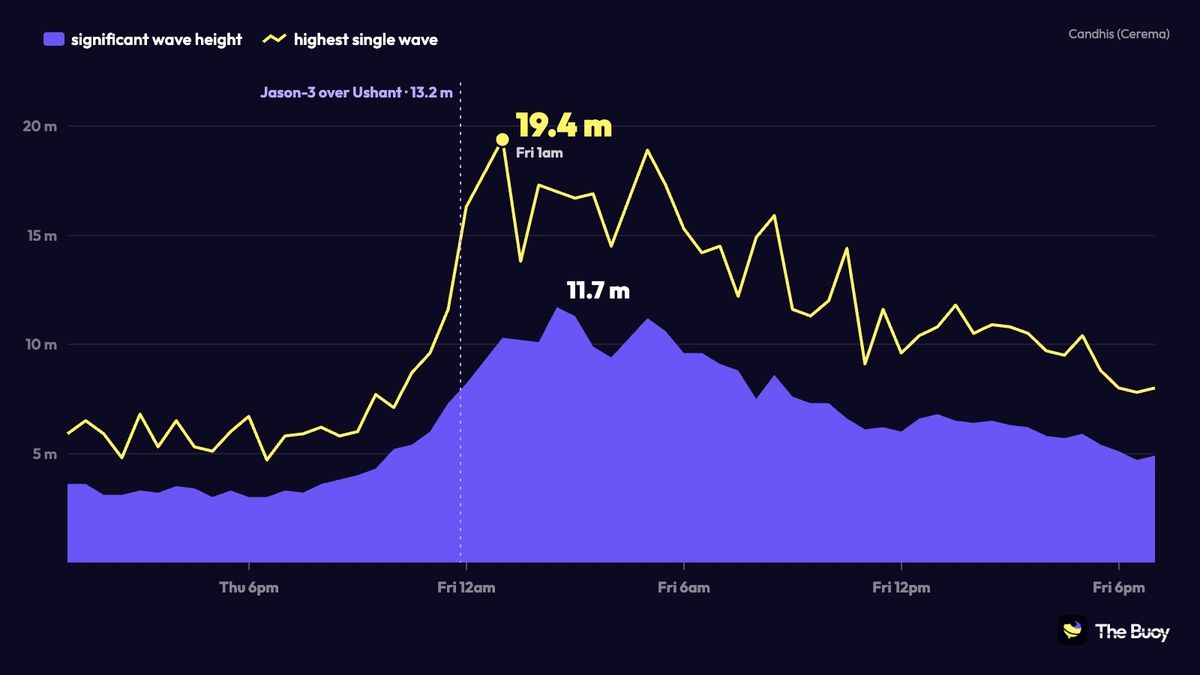
The low comes in from the west and passes off Cornwall: pressure drops to 975 hPa on the Isles of Scilly around midnight. At 11:51pm, the Jason-3 satellite flies over the Iroise Sea and measures 13.2 m about 100 km west of Ushant, the highest satellite reading of the whole storm.
An hour later, at 1am UK time, the Pierres Noires buoy records a 19.4 m wave. The significant wave height peaks at 11.7 m around 2:30am and stays above 9 m until morning. On the coast, gusts reach 158 km/h on Ushant, 152 km/h at Pointe du Raz and 150 km/h on Groix.
Fri 23, morning
The Bay of Biscay
- 18.1 mhighest wave at Belle-Île →
- 13.4 mhighest wave at Anglet →
- 10.6 mHY-2B near Belle-Île
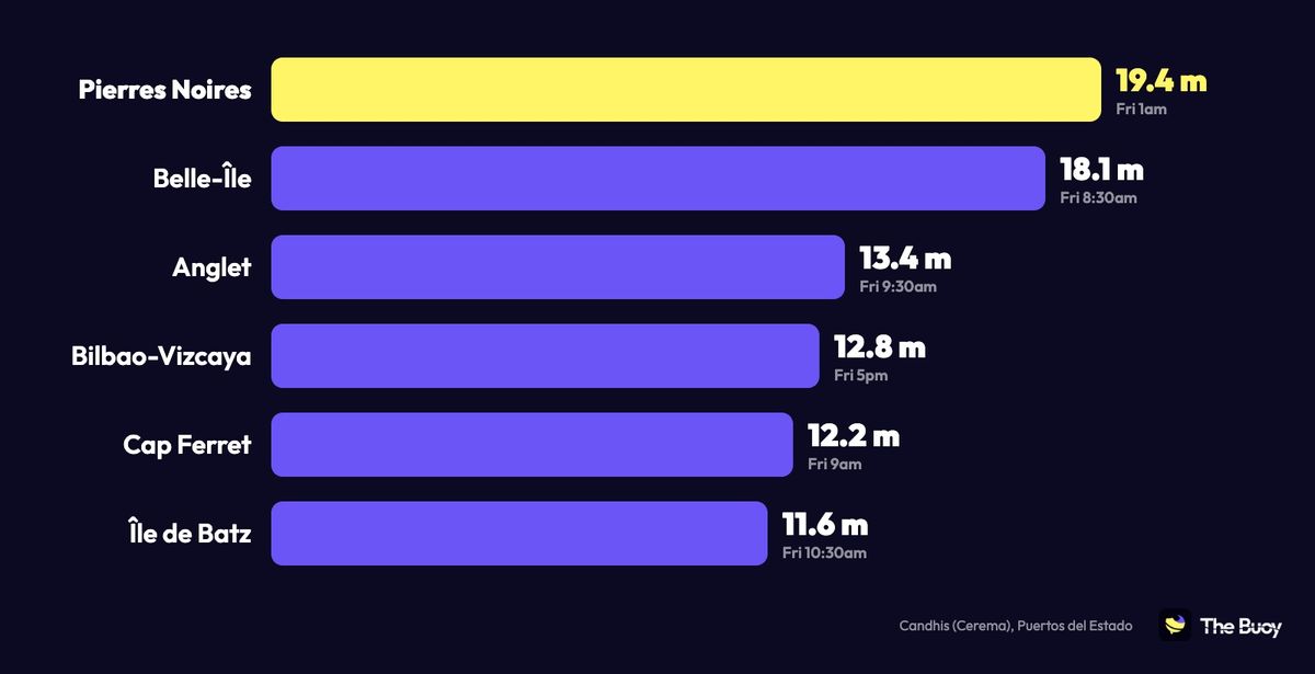
The swell then runs south. At Belle-Île, the buoy measures 10.2 m with an 18.1 m wave around 8:30am. The Chinese satellite HY-2B passes nearby at 8:02am and reads 10.6 m, about 50 km to the west. Offshore, Météo-France's Gascogne buoy reaches 9.3 m at noon.
Along the Aquitaine and Basque coasts, single waves top 12 m: 12.2 m at Cap Ferret, 13.4 m at Anglet, 12.8 m at the Bilbao-Vizcaya buoy late in the day. In the Basque Country the measured swell beat the forecast: at Bilbao, the energy per wave at the peak was about 40% above what the ECMWF model predicted.
Fri 23, midday
The low tracks up the Channel
- 976 hPalow off Cap de la Hague
- 148 km/hgust at Fécamp
- 5.3 mswell in Poole Bay →
Meanwhile the low tracks up the Channel. It passes closest to Cap de la Hague around 6am (976 hPa), then Le Touquet at 11:30am and Bergues, near Dunkirk, around 12:40pm. Behind it the wind stays violent: 148 km/h at Fécamp mid-morning. On the English side, the swell reaches 5.3 m in Poole Bay and 4.3 m at Hastings.
Sat 24, morning
The North Sea, then nothing
- 5.3 mswell at the J6 platform →
- 5.2 mswell at Borssele →
- 1.6 mat most in Denmark
Austen leaves through the North Sea overnight into Saturday. The north-westerly behind the low raises a rough sea along the Belgian and Dutch coasts: 5.2 m at Borssele around 3:40am, and 5.3 m at the J6 platform around 6am, slightly above the 4.7 m the German model expected.
And Denmark? It was on the forecast track but barely felt it: 1.6 m at most on its west coast buoys. The storm ran out of steam before getting there. That same evening, another storm, Boelo, reached Scotland.
Key numbers
- 19.4 m: the highest wave measured, at the Pierres Noires buoy, Friday 1am.
- 13.2 m: the highest significant wave height seen by satellite (Jason-3, 11:51pm Thursday).
- 11.7 m: the highest significant wave height measured by a buoy (Pierres Noires).
- 158 km/h: the strongest coastal gust, on Ushant.
- 975 hPa: the low at its deepest, over the Isles of Scilly then Cap de la Hague.
Method and sources
All these measurements are on The Buoy: buoys from Cerema's Candhis network, Météo-France, Puertos del Estado, Cefas and Rijkswaterstaat; weather stations from Météo-France, the Met Office and Infoclimat; and altimetry satellites through Copernicus Marine (European Union). Faulty readings were left out, for example the Perranporth and Bideford buoys in Cornwall, whose sensors failed during the storm. Candhis data, cut off from 22 to 27 October, has since been recovered. UK times.
Buoys in this story
Download the app for more features
Access historical readings and compare readings with the forecast


No mandatory subscription or ads everywhere — a coffee helps keep servers running and the app improving.